DOWN THE COLORADO THROUGH THE GRAND CANYON Part 2
This mini-guide of river-running highlights contains just a sampling of the sights
along the river. Even so, it would be tough to fit them all into a single trip.
Experienced river guides know far more places, including some "secret"
ones that they may share with you. Weather, schedules, and camps of other river
parties will affect which places your group will decide to take in. Rapids with
ratings of five or more on the Grand Canyon's one-through-ten scale are listed in
parentheses; flow rates greatly affect some rapids, hence the range given for them.
The place descriptions come from the author's experience on two river trips and
advice from river guides and National Park Service staff. Geologic information is
mostly from the out-of-print book River Runner's Guide to the Canyons of the
Green and Colorado Rivers: With Emphasis on Geologic Features, Vol. III by
George C. Simmons and David L. Gaskill (Northland Publishing, 1969).
Mile 0: Lees Ferry
This historic site along the Colorado
River, once the only easily accessible crossing for hundreds of miles upstream or
down, now marks the beginning of river voyages into the Grand Canyon. Most boaters
have only one thing on their minds here—getting on the river and embarking
on their adventure! Yet it's worthwhile to come early or at another time to explore
Lonely Dell Ranch, other historic buildings, and remnants of past mining attempts
at Lees Ferry. Spencer Trail beckons hikers from the rim of the canyon, and the
far more gentle Cathedral Wash route offers a walk to the river below. The Paria
Canyon hike, one of the finest in the region, ends here after four to six days of
twisting through its wonderful sandstone walls from a trailhead north across the
Utah border. Then some people come to fish or just relax by the cold, clear, trout-filled
river. See the Lees Ferry section for details on the
area and Below the Vermilion Cliffs for nearby
lodging, camping, and restaurant information.
|
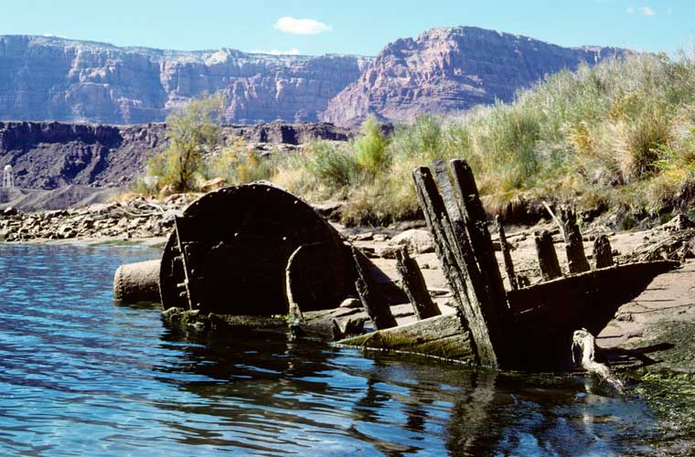
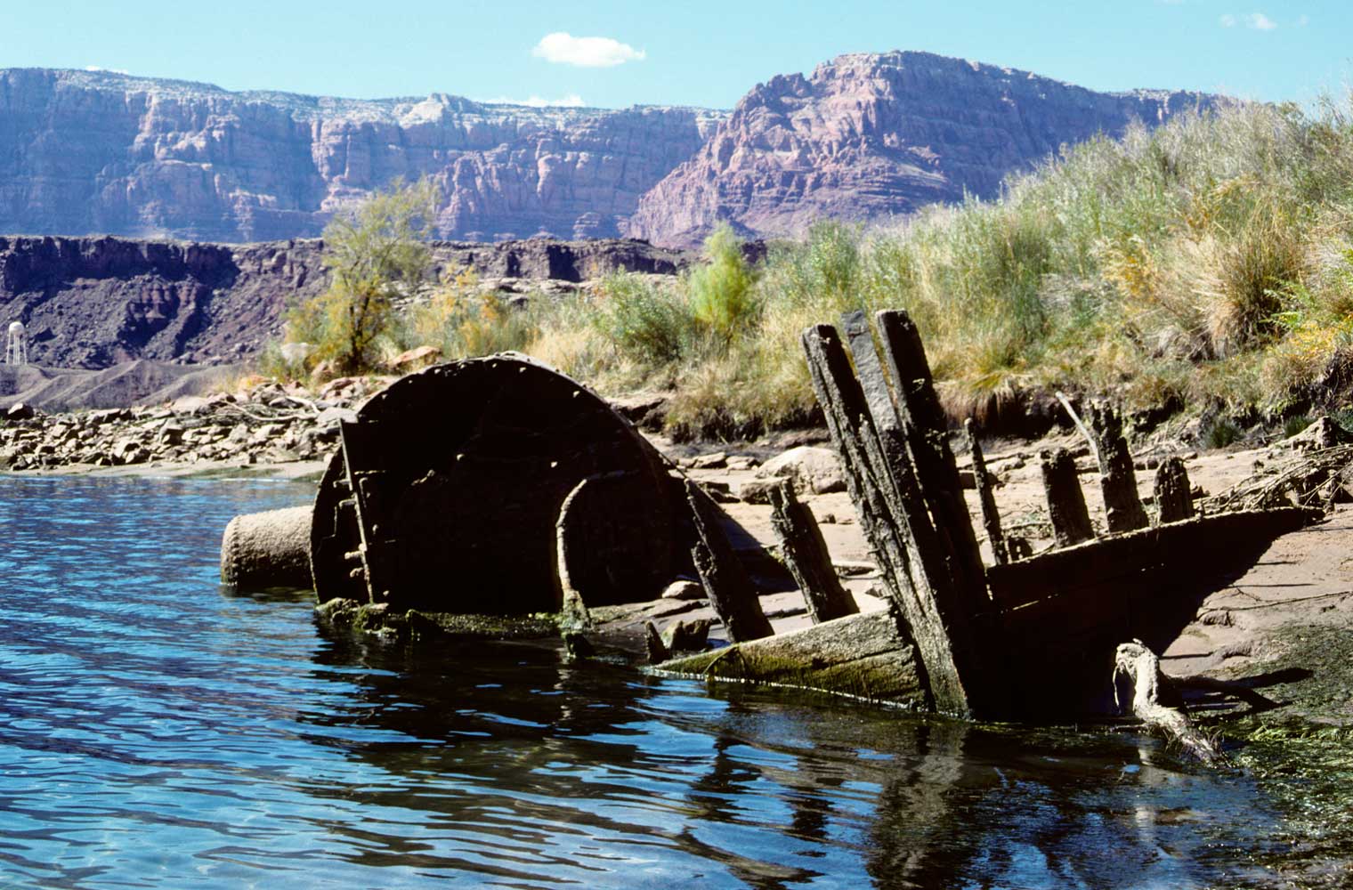
wreck of the Charles H. Spencer
(launched in 1911) at Lees
Ferry
Miners and farmers came to try their luck along
the Colorado River and its tributaries. Charles Spencer, manager of the
American Placer Company, brought in sluicing machinery, an amalgamator,
and drilling equipment. In 1910 his company tried mule trains to pack coal
from Warm Creek Canyon, 15 miles upstream. When the mules proved inadequate,
company financiers shipped a 92-foot-long steamboat, the Charles H.
Spencer, in sections from San Francisco. The boat performed poorly,
burning almost its entire load of coal in just one round trip, and was used
only five times. The boiler, decking, and hull can still be seen at low
water on the shore upstream from Lee's Ferry Fort. Although Spencer's efforts
to extract fine gold particles proved futile, he persisted in his prospecting
here as late as 1965 and made an unsuccessful attempt to develop a rhenium
mine.
|
You're now at an elevation of 3,116 feet. A descent of 1,936 vertical feet lies
ahead as you plummet deep within the Grand Canyon through more than a dozen geologic
formations before meeting the Canyon's last riffles near Separation Canyon, where
the river meets Lake Mead. Note how the types of rock affect the river and thus
your ride—wide and smooth through the soft shales, then narrower and bumpier
in the sandstone, limestone, granite, and schist—but be ready for surprises
where tributaries have dumped huge piles of rocks into the river!
Rock layers visible near Lees Ferry formed during the Triassic and Jurassic Periods,
roughly 240-140 million years ago, when the dinosaurs first appeared and walked
this land. Rocks of this age actually once lay atop the older layers seen on the
much higher rims of the Grand Canyon, but there they've been reduced by erosion
to just a few remnants like Cedar Mountain, visible from Desert View. Dramatic folding
and faulting downstream have raised the Colorado Plateau thousands of feet, which
you'll soon plunge into. The sights mentioned below follow the convention of "river
right" and "river left" facing downstream.
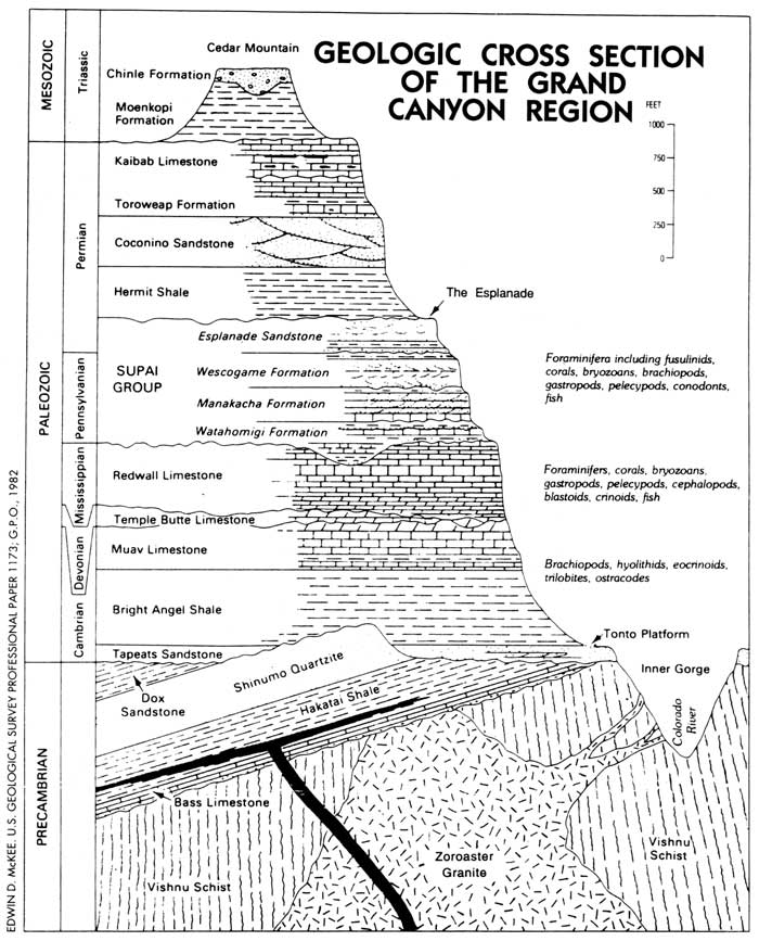
Canyon Rocks
With 94 types of rock discovered in the Grand Canyon, how does
one remember even the major formations? All you have to do is remember "Know
the canyon history. See rocks made by time very slowly."
Know..................Kaibab Limestone
The.....................Toroweap
Canyon...............Coconino Sandstone
History...............Hermit
Shale
See.....................Supai Group
Rocks.................Redwall
Limestone
Made..................Muav Limestone
By.......................Bright
Angel Shale
Time...................Tapeats Sandstone
Very
slowly........Vishnu Schist
|
Mile 0.8: Kaibab Formation
Look on the left for the emergence
of the Kaibab Formation, the cream-colored, weather-resistant limestone that caps
much of the Grand Canyon rims. Scientists have found fossils of marine invertebrates
and some fish. You've now crossed a major geologic time boundary into the Permian
Period (290-240 million years ago) of the Paleozoic Era.
Mile 1: Paria Riffle
The Colorado gets some of its namesake
reddish color here if the Paria River (on the right) is flowing. Marble Canyon begins
downstream from here. Major Powell and his men saw the sheer, polished walls from
here down to the Little Colorado confluence and named this section Marble Canyon,
although no marble is actually present.
Mile 2: Toroweap Formation
This silty limestone, formed near
the sea's edge, was also deposited during the Permian Period. The Toroweap has thinner
beds and less chert than the Kaibab.
Mile 4: Coconino Sandstone
Tilted crossbedding, reptile tracks,
and even imprints of raindrops indicate windblown deposits—ancient sand dunes
built up during the middle of the Permian Period. By comparing the angles of the
crossbedding with modern sand dunes, geologists have concluded that winds had blown
the sand from the north.
Mile 4.5: Navajo Bridge
The bridge, recently built beside
its 1929 cousin, connects the canyon rims 470 feet above. In 1937, river runner
Buzz Holmstrum stopped near here to get supplies at what looked on his map like
the nearby Marble Canyon store. He did make it up and down the cliff somehow, then
went on to make the first intentional solo run through the Grand Canyon.
Mile 7: Hermit Shale
Fossils of ferns, other plants, and
even some insects have been collected from this soft reddish shale. The rock formed
in a vast river floodplain in the early part of the Permian Period.
Mile 8: Badger Creek Rapid (5-8)
Your first of many exciting
rapids, it was created by the outwash from ephemeral streams of Badger Canyon on
the right and Jackass Canyon on the left. A rough three-mile trail connects the
river to US 89A via Jackass Canyon; Navajo sometimes come down this way to fish.
Hikers can scramble up Badger Canyon about a mile. Badger and nearby Soap Creek
got their names when 19th-century Mormon explorer Jacob Hamblin shot a badger, took
it back to camp, stewed it overnight, then found that the alkaline water had turned
the fat in his breakfast into soap!
Mile 11.2: Soap Creek Rapid (5-6)
Soap Creek comes in from
the right. This rapid marks the beginning of a series of tragic sites for the 1889
Stanton-Brown survey, who came to study a proposed railroad route through the Grand
Canyon. Despite having portaged the rapid, Frank M. Brown, the organizer of the
Denver, Colorado Canyon, and Pacific Railroad Company, drowned below here. Five
days later two other members drowned before the group abandoned their work and climbed
out of the Canyon. The following year, Robert B. Stanton and a team returned equipped
with lifejackets and better gear to complete the survey.
The Supai Group exposed here comprises four formations that contain fossils of
plants deposited in ancient delta deposits. Tracks of primitive reptiles have been
found in the upper half of the group. First, you'll see reddish-brown sandstone
of the early part of the Permian Period (about 280 million years ago) with thinner
layers of ripple-marked siltstone and shale. The rock commonly weathers into ledges.
Below are rocks of the Pennsylvanian Period (330-290 million years ago)—crossbedded
sandstone in the middle part of the group, then thin-bedded sandstone with much
interbedded siltstone and mudstone in the lower part.
Mile 12: Salt Water Wash on the left
A rough route climbs
about four miles up to US 89A; lots of boulders in the lower half make for slow
going.
Mile 16.9: House Rock Rapid (7-9)
Rider Canyon comes in from
the right. Robert B. Stanton used this difficult canyon route during his second
expedition in 1890 to carry out an injured photographer who had fallen from a 20-foot
cliff.
|
North Canyon, one of the many beauty spots
easily accessible from the Colorado River
|
Mile 20.5: North Canyon Rapid (5)
You've now entered the "Roaring
20s"—a lively section of rapids in Marble Canyon. North Canyon, on the
right, offers beautiful hiking. It's less than a mile to where cliffs block the
way; pools and small waterfalls may be present.
Mile 21.2: 21 Mile Rapid (5)
Mile 23: Redwall Limestone
Perhaps the most distinct layer
in the Grand Canyon, the Redwall forms long, unbroken cliffs. Here it makes up much
of the impressive walls of Marble Canyon. The Redwall challenges skills of trail
builders and hikers who attempt rim-to-river routes. The upper Redwall contains
many caves; sometimes you'll even see matching caves on both sides of the river.
The red color comes not from the limestone itself, but from stains of the Hermit
Shale above. Fossils of nautiloids (straight and spiraled), corals, brachiopods,
crinoids, and sponges show that the limestone was deposited on the floor of a shallow
sea in the Mississippian Period (360-330 million years ago).
Mile 23.3: 23 Mile Rapid (4-6)
Mile 24.2: 24 Mile Rapid (6-8)
Mile 24.5: 24-1/2 Mile Rapid (5-6)
Mile 24.9: 25 Mile Rapid (5-7)
It's also known as Hansbrough-Richards
Rapid in memory of these two members of the trouble-plagued Stanton-Brown railroad
survey expedition of 1889. They drowned when their boat capsized just after they
lined it through the rapid.
Mile 25.3: Cave Springs Rapid (5-6)
Mile 26.6: Tiger Wash Rapid (4-5)
Tiger Wash is on the left.
Our crew had mixed emotions on this April morning when we awoke to sleet
falling on camp near Silver Grotto. Snow covered the canyon walls above.
The rest of the group sensibly stayed in their sleeping bags. Soon the sun
broke through the gray mist and we had a great day on the river. |
Mile 29.2: Silver Grotto and Shinumo Wash on the left
In
warm weather, boaters clamber up into the narrow canyon of lower Shinumo Wash and
swim several icy pools to Silver Grotto. You can also see Silver Grotto from above
by pulling over on the left at Mile 30.1 and hiking back upstream on the Fence Fault
Route. Shinumo Altar rises from the south side of Shinumo Wash; the name comes from
the Paiute word for the former inhabitants (ancestral pueblo people) of the area.
Mile 30: Redwall Dam Site
This spot is remarkable for what
you don't see! Recognized as one of a series of potential dam sites by
government surveys in the 1920s, it was later proposed by the Bureau of Reclamation
as the site for a dam that would have raised the water 222 feet in a lake stretching
nearly to Lees Ferry.
Mile 31.6: South Canyon on the right
South Canyon provides
hikers with a route from the rim.
Mile 31.8: Stanton's Cave on the right
High up (150 feet)
in the Redwall you'll see a large cave entrance. The name honors Robert B. Stanton,
chief engineer of the 1889 and 1890 Brown-Stanton railroad expeditions, who used
the cave to store gear when the demoralized first expedition walked out South Canyon.
Archeologists value the cave for the split-twig figurines left behind thousands
of years ago and for more recent pottery and granaries left by the ancestral pueblo
people. The Park Service has closed it to the public.
Mile 31.9: Vasey's Paradise on the right
Springs transform
the shore into a beautiful oasis of flowers, maidenhair fern, mosses, and poison
ivy. The Park Service recommends that visitors not enter the vegetated area because
of endangered Kanab ambersnails, found only here and at one spot in southern Utah.
George W. Vasey worked as a botanist with Major Powell on a 1868 expedition to what's
now the state of Colorado.
Mile 33: Redwall Cavern on the left
Major Powell thought
that this giant alcove could serve as a theater seating 50,000 people, but allowed
that "at high water the floor is covered with a raging flood." Today it's
a popular stop, though camping isn't permitted.
Mile 34.8: Nautiloid Canyon on the left
Stop to see large
fossils of chambered shells, from an animal related to squid, embedded in the floor
of the canyon.
Mile 35: Muav Limestone (river level) and The Bridge of Sighs (high on
the right)
The contact between the Redwall and the underlying Muav can
be difficult to see; at places a small slope or a bench marks the line. The Muav
was deposited in a sea about 535 million years ago during the Cambrian Period; it
has very few fossils. The Bridge of Sighs, a natural arch, appears high on the right.
Mile 43: Point Hansbrough and Anasazi Bridge high on the right
A log bridge survives from a prehistoric trail of ancestral pueblo people.
The river begins a big loop to the right around the point. The second Stanton expedition
found the skeleton of Peter Hansbrough here six months after he had drowned at 25
Mile Rapid.
|
view from Eminence Break Trail
|
Mile 43.7: President Harding Rapid (4)
A U.S. Geological
Survey expedition came through in 1923, led by Claude Birdseye, to make the first
detailed maps of the Canyon and to survey potential dam sites. It also carried the
first radio receiver into the Canyon. After hearing earlier of the president's death
on the radio, the group stopped here for a day in observance of the president's
funeral. Eminence Break Trail on the left beside the rapid climbs out to the rim;
you'll enjoy great panoramas on the way up. The upper trailhead (difficult to find)
can be reached by road (difficult to navigate); see "Tatahatso Point"
in Western Navajo Country.
Mile 46.6: Triple Alcoves on the right
|
Saddle Canyon
|
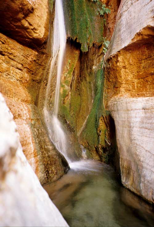
Mile 47: Saddle Canyon on the right
Hike up one mile to pools
and a little waterfall. Redbud trees flower in the spring in shady recesses.
Mile 50: Bright Angel Shale
This purple and green shale formed
in the sea during the Cambrian Period about 550 million years ago.
Mile 51.9: Little Nankoweap Creek on the right
Like many
tributaries, this canyon becomes prettier as you head upstream; cliffs eventually
block the way. Redbud trees and pools add to the beauty.
|
Sam Jones at the oars in Nankoweap Rapid
|
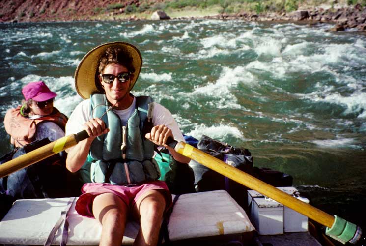
Mile 52.2: Nankoweap area
Nankoweap Rapid (3) offers a long
ride, but hiking in the area draws the most attention. The Nankoweap and Little
Nankoweap form a large delta with many places to camp and explore. A short, steep
hike leads up to an impressive row of granaries constructed by ancestral pueblo
people. During 900-1150, they built many structures on the section of river between
here and Unkar Delta (Mile 72.5). Hikers could spend days exploring Nankoweap Canyon
and its tributaries or even hike out to the North Rim on the Nankoweap Trail. Most
river runners prefer shorter explorations in the area. A good loop daytrip begins
by hiking up the Nankoweap about two miles, turning south up the first major draw
and down the other side to Kwagunt Creek, then following Kwagunt back to the river,
where either you're met by the other boaters in your party or you hike up the Colorado
back to Nankoweap; plenty of water and a sun hat will be needed for this spring
or autumn trek.
Mile 56: Kwagunt Rapid (6)
Kwagunt Creek on the right can
be explored on foot.
Mile 60: Tapeats Sandstone
The brown, medium- to coarse-grained
sandstone formed about 570 million years ago during the Cambrian Period.
|
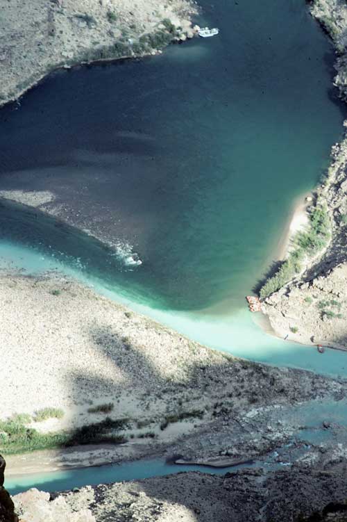
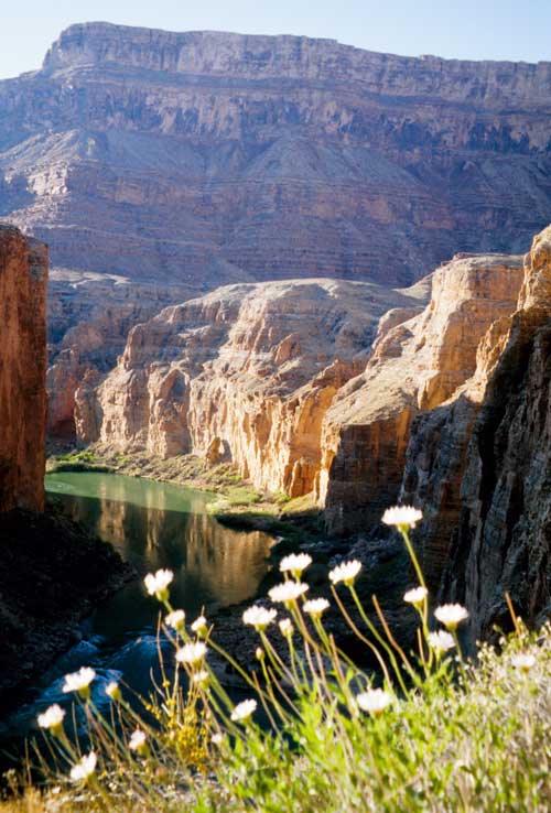
Confluence of the Little Colorado River (coming
in from the lower right) and the Colorado (coming in from top), viewed from
Cape Solitude on the Canyon rim. The large rafts beached where the rivers
meet can barely be seen from this height.
Cape Solitude lives up to its name and features
amazing views of both canyons; the jeep road has been closed to vehicles,
but adventurous drivers with 4WD can take backroads on the Navajo Reservation
(tribal permit needed) to the Park boundary, then walk the last 6.7 miles.
When the Little Colorado isn't in flood, you'll see blue waters from mineral-rich
springs in its canyon. Hikers can reach Blue Springs on a very rough route,
estimated at 1.5 miles and an elevation change of 2,100 feet each way; it's
on the Navajo Reservation (tribal permit required) and approached on 4WD
roads from Desert View via Cedar Mountain or from the Kaibab National Forest
farther east. The Little Colorado offers a challenging hiking route between
Cameron and the Colorado River; conditions constantly change, and it should
be avoided when in flood. Hiking books describe some of these routes. Ask
around at Desert View, Tusayan Ruins, and the Backcountry Office to find
a ranger knowledgeable in these areas. See the Cameron section in "Western
Navajo Country" for details on obtaining Navajo tribal permits to explore
this remote country east of the Grand Canyon.
|
Mile 61.4: Little Colorado River on the left
This major tributary
of the Colorado has two colors! During spring snowmelt or summer storms in the mountains
of eastern Arizona, the Little Colorado carries a heavy load of brown silt. In dry
periods, the only flow comes from mineral-laden Blue Spring, 12.5 miles upstream.
The water becomes a beautiful aquamarine due to the salts and calcium carbonate;
it's not drinkable. Endangered fish hang out near the confluence, so no fishing
or camping here.
You can hike up the Little Colorado nearly a mile to see Beamer's stone-slab
cabin on the south bank. Ben Beamer came here in 1889 to prospect and do a bit of
farming; he likely "borrowed" stones from ruins left by ancestral pueblo
people to build his cabin. Beamer's Trail still connects the confluence with Tanner
Rapid downstream and the Tanner Trail to the South Rim.
Back on the Colorado River, you'll spot some salt deposits along the left bank
in the next three miles. Hopi Indians once made long pilgrimages from their villages
to collect this salt. The salt mines remain sacred to the Hopi, hence Park Service
rangers prohibit others from visiting them. Instead, wait until Mile 119.8, where
you can stop and take a close look at a salt deposit.
On to Part 3