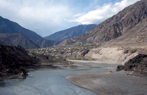
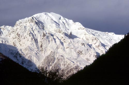
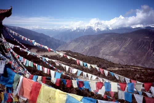
View up the Yangzi near Benzilan
Deqin, China
31 March 2005
In Shangri La
Dear Friends and Family,
This town, nestled in a valley high above the Mekong River, is the sort of place where you might meet a couple of yaks at the main intersection. If you are wondering what Shangri La is like at the moment, today it is cold, wet, and miserable.
Getting here was all adventure. After a couple restful days in Zhongdian visiting the huge Ganden Sumtseling Gompa north of town and a couple small gompas in town, I headed northwest toward the clouds. After climbing a ridge and a small pass, I sped down into a long valley, climbed another small pass, then hurtled down, down, down into ever deepening canyons until I reached the swift Yangzi River. On the way I passed some villages with terraced fields full of green crops and flowering fruit trees. It felt good to leave the grip of winter behind and reenter springtime! The canyons would have fitted in well next to Arizona's Grand Canyon. The sheer rock walls had hardly any vegetation. Some prickly pear cactus completed the scene. Smooth asphalt continued as the road crossed the river and continued upstream to the town of Benzilan, where I enjoyed a comfy room with hot shower for only $6.
View
up the Yangzi near Benzilan
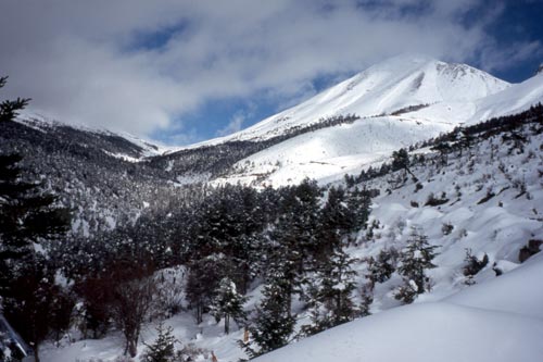
On Day 2 out of Zhongdian, the climb started. At first the weather was warm with bits of sun as I ascended high above the Yangzi River valley and its ever-deeper tributaries. Periods of light rain began as I crossed a ridge and passed a Tibetan monastery and small villages clinging, along with their terraced field, to the steep hillsides. A little restaurant in one of the villages served up some welcome noodle soup and tea, before I headed back into the mists. Soon I was past the last village and among conifer forests and snowy mountains. Where would I stay the night amongst all this snow? I kept riding and the weather gradually improved. The altitude slowed me a bit, but it was the end of the asphalt and beginning of cobblestones after 42 km that most crimped my style. The snow was about half a meter deep when I spotted an abandoned road workers hut, 44 km and 6 hours up the mountain. I set up camp inside then watched the snowy mountains all around as the clouds drifted away. The pass beckoned 13 km to the northwest, but I was content to stay where I was.
From my camp that evening, the clouds lifted to reveal the first of the triple passes
(on the left).
Morning dawned bright and sunny as I stirred from my warm sleeping bag and got ready for the triple pass. It was slow going for that last bit to the first pass, signed as 4,000 meters, but my biggest obstacles were traffic jams. Only one lane of the road had been cleared of snow, but the one-way traffic system didn't work. Buses and trucks got stuck in ditches or icy patches and everyone tried to pass everyone else. I would drag the bicycle through snowdrifts around the stuck vehicles only to encounter another jam. Eventually everyone was on their way and I reached the pass, just above treeline, then down and up to the second pass and another down and up to the third pass, around 4,300 meters high. Some short sections of icy snow required walking, but I made it safely through all of them. A group of enthusiastic Chinese tourists were enjoying a snowball fight and photo snapping at the third pass; I got my photo taken but was spared the snowballs. Weather had been surprisingly warm at the passes thanks to some hazy sun mixed with a light snowfall; a wind jacket was all I needed. But when it came time to head down, I put on my down gear and layers before dropping into the dark valley below. Slushy snow on the road at the passes had soaked into my shoes and my feet felt like blocks of ice on the downhill. As I descended I could begin to make out the immensely deep valleys leading to the Mekong River and the great snow mountains on the other side. Finally Deqin came into view and I pedaled past the yaks and found a simple Tibetan hotel with a hot shower.
Deqin is a small town of mostly unattractive concrete box architecture, but does have everything a traveler or Tibetan would need. The Tibetan shops are fun to browse—they're the place to pick up a horse saddle, a fur-trimmed dress, stove, carpets, or some chunky jewelry. The shops remind me of an old-style Navajo trading post in the American Southwest!
Today I'm taking a rest and playing on the Internet, which is just as well due to the persistent light rain. Tomorrow I'm hoping for sunnier skies, when I swing across the other side of this valley to a viewpoint, then plunge down to the Mekong River and nearby Mingyong Glacier. I suspect the Mekong will look somewhat different than the river I know from Thailand and Laos!
Although I'm near the border with Tibet, my plan is to retrace my tracks over the triple pass back to the Yangzi River, then turn north into Sichuan Province and the Tibetan-inhabited highlands there. I have many more 4,000+ meter passes to cross before I box up Bessie Too for the flights home.
Your man and bicycle in Shangri La,
Bill Weir and "Bessie Too the Bicycle"
Danba, Sichuan Province, China
18 April 2005
To the ends of Yunnan
Dear Friends and Family,
Yunnan has been one of the most amazing places I've ever visited. Geographically I have ridden from the sunny tropics to the Himalayan snows, all within Yunnan! The cultural contrasts have ranged from the Southeast Asian tribal groups in the south to the Chinese of the center and finally to the Tibetan people of the north. All three major branches of Buddhist practice are here too—Theravadan in the south (as in neighboring Laos and Burma), Mahayana in the center (as in most of China), and the most colorful of all, Tibetan in the north. Muslims have settled throughout the province; most are ethnically Chinese, but the atheist Chinese government considers Muslims a minority group because of their religion. People have been friendly throughout—I highly recommend a visit to this part of the world!
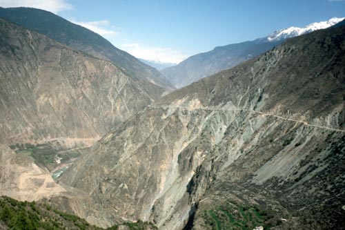
After a well-deserved rest day in Deqin, I set out for the Mekong River. The day dawned cloudy with a light snowfall—nothing new. Before the big descent, I followed the road as it contoured around the side valley above Deqin to a viewpoint (no views today), then I began the long atmospheric downhill. Clouds drifted in and out, revealing views of villages, cliffs, the deep valley of the Mekong, then finally the river itself. I felt awfully small in the vast gorge. At a switchback, a gravel road continued north high above the river on the long journey to Lhasa in Tibet; perhaps another time...
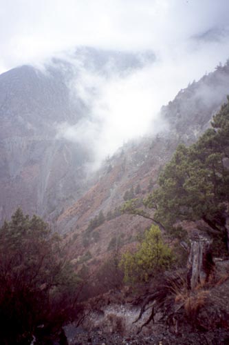
Misty
mountains above the Mekong River
Just before the bridge, a ticket office charge me about $7.50 admission for Mingyong Glacier. That seemed high, but I would find out why later. The road crossed a concrete arch bridge over the swift and turbulent Mekong, then turned up a side valley to Mingyong Village and the start of the hike to the glacier. I took a room in a hotel, then hit the trail. In an hour I reached an observation platform with a fine view of the lower glacier, heavily crevassed. That was nice, but heading back I found another trail that led high above the glacier. Walkways clung to the cliffs and took me up past a gompa (Tibetan temple), then higher still to an elaborate series of platforms spectacularly situated above the edge of the glacier. Sounds of cracking, thumping, and crashing of ice reverberated in the valley—the Mingyong Glacier moves at an average of 500 meters a year, unusually speedy for a river of ice. The glacier begins high on the slopes of beautiful Kawa Karpo (6,740 meters) and flows 11.8 km with an average width of 500 meters. A few small turquoise-colored lakes settled on the lower part, but most of the ice was jumbled and cracked.
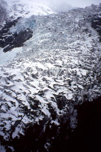
Mingyong
Glacier
The next morning, the most amazing thing happened. The sun came out! I watched the sunrise illuminate Kawa Karpo. I retraced my route back to Deqin, riding in shorts and short sleeves for the first time in a long while. The sun was out the next day too, and I was so enthused that I rode over the triple pass and all the way down to Benzilan on the Yangzi River in one long day—104 km. Countless snow mountains lay all around as I rode along. I could relax and enjoy the scenery now that the snowstorms had stopped and the ice had melted from the road. So which of the triple passes was the real divide between the Yangzi and Mekong? It was the pass closest to Deqin and also the one with the best mountain views. The middle pass was actually over a ridge between two branches of a tributary of the Yangzi. And the third pass stood high above the Yangzi itself.
The magical view of Kawa Karpo from the roof of my guest house in Mingyong Village
View north toward Tibet; the unpaved road on the right heads up the Mekong River
valley
and seems to be the preferred route for cyclists trying to sneak into
Tibet without a permit.
Some cyclists make it to Lhasa without getting arrested,
some don't. You can see the
Mekong River deep in its gorge on the left. Northernmost
Myanmar and the extreme northeast
corner of India—both
extremely remote regions—lie across the mountains to the left (west).
The road from Deqin climbs the valley wall on the left, then continues to Mingyong
Village and Tibet .
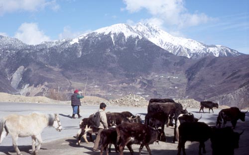
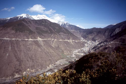
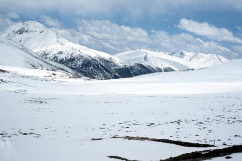
Morning
rush hour above Deqin
View
southwest toward the Mekong River valley
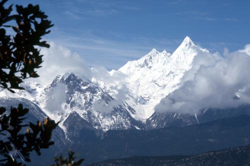
In
the same Meili Xueshan range as Kawa Karpo, the beautiful peak of Miacimu (6,054
meters or 19,862 feet) represents the female counterpart of Kawa Karpo.
Miacimu so entranced 20th-century explorer Joseph Rock that he called it "...the most glorious peak my eyes were ever privileged to see...like a castle of a dream, an ice palace of a fairy tale..."
View
south from the main pass, high above Deqin
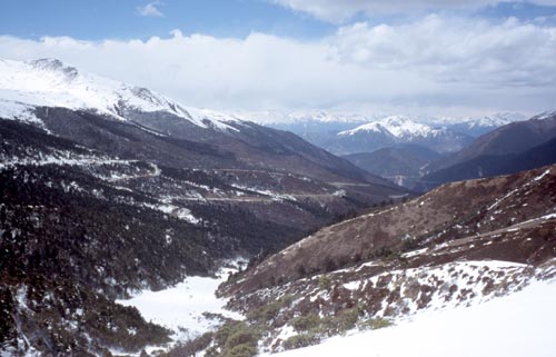
From
the last pass the road makes long, lazy loops down to the Yangze.
I thought that the triple pass ride would have wiped me out, but I was ready for another ride the next morning. A rusty little ferryboat carried me across the Yangzi and into Sichuan Province, where I turned up a bumpy gravel road along the deep, arid canyon of the Yangzi. From the top of the world the previous day, I now felt like I was in the depths of the earth! I reached Derong, a dirty town, but at least I got a hot shower to wash the dust off.
From the high mountains and deep canyons,
Bill and "Bessie Too the Bicycle"