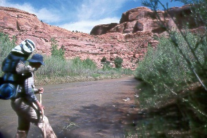
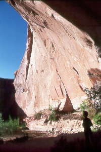
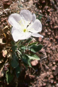
 Colleen
Huston in Escalante River Canyon (above Silver Falls Creek)
Colleen
Huston in Escalante River Canyon (above Silver Falls Creek)
Colleen
Huston in Escalante River Canyon (above Silver Falls Creek)
The Escalante River's maze of canyons presents exceptional hiking opportunities. You'll find everything from easy day hikes to challenging backpacking treks. The Escalante's canyon begins just downstream from the town of Escalante and ends at Lake Powell about 85 miles beyond. In all this distance only one road (UT 12) bridges the river. Many side canyons provide additional access to the Escalante and most are as beautiful as the main gorge. The river system covers such a large area that you can find solitude even in spring, the busiest hiking season. The many eastern canyons remain virtually untouched. The Escalante canyons preserve some of the quiet beauty once found in Glen Canyon, now lost under the waters of Lake Powell. Prehistoric Anasazi and Fremont Indians have left ruins, petroglyphs, pictographs, and artifacts in many locations. These archaeological resources are protected by federal law. Please don't collect or disturb them.
|
|
|
Clear shallow water glides down lower Harris Wash, a gem of a canyon. High cliffs streaked with desert varnish are deeply undercut and support lush hanging gardens. Harris Wash provides a beautiful route to the Escalante River, but it can also be a destination in itself; tributaries and caves invite exploration along the way. The sand and gravel streambed makes for easy walking. Harris Wash is 10.25 miles one way from trailhead to river. Reach the trailhead from the town of Escalante and UT 12 by turning south 10.8 miles on Hole-in-the-Rock Road, then left 6.3 miles on a dirt road (keep left at the fork near the end). Don't be dismayed by the drab appearance of upper Harris Wash. The canyon and creek appear a few miles downstream.
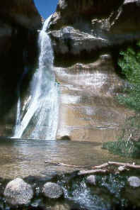 Lower
Calf Creek Falls, east of the town of Escalante
Lower
Calf Creek Falls, east of the town of Escalante
The hike to Lower Calf Creek Falls offers a good introduction
to the pleasures of hiking in the Escalante River system. Walking between high cliffs
of Navajo Sandstone streaked with desert varnish, you'll see beaver ponds, Indian
ruins and pictographs, and the misty 126-foot-high Lower Calf Creek Falls. Roundtrip
distance is 5.5 miles with only a slight gain in elevation; bring water and perhaps
a lunch. Summer temperatures can soar but the falls and the crystal-clear pool beneath
stay cool. Sheer cliffs block travel farther upstream. The trail begins from Calf
Creek Campground, 15.5 miles east of Escalante on UT 12. A brochure available at
the trailhead identifies many of the desert and riparian plant species along the
way.
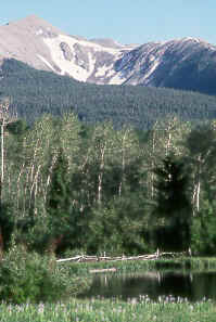
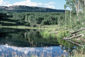 Chriss
Lake, reached by trail off Boulder Mountain Scenic Drive,
Chriss
Lake, reached by trail off Boulder Mountain Scenic Drive,
north of Boulder
Utah 12 climbs high into forests of ponderosa pine, aspen, and fir on Boulder Mountain between the towns of Boulder and Torrey. The modern highway replaces what used to be a rough dirt road. Travel in winter is usually possible now, though heavy snows could close the road. Viewpoints along the drive have sweeping panoramas of the Escalante canyon country, Circle Cliffs, Waterpocket Fold, and the Henry Mountains. Hikers and fishermen can explore the alpine country of Boulder Mountain and seek out the 90 or so trout lakes. The Dixie National Forest map (Escalante and Teasdale ranger districts) shows the back roads, trails, and lakes. The U.S. Forest Service has three developed campgrounds about midway on this scenic drive: Oak Creek (18 miles from Boulder; elev. 8,800 ft.), Pleasant Creek (19 miles from Boulder; elev. 8,700 ft.), and Singletree (24 miles from Boulder; elev. 8,600 ft.). Season with water lasts from about mid-May to mid-Sept.; Singletree may stay open through October at half price without water. Lower Bowns Reservoir (elev. 7,400 ft.) has primitive camping (no water or fee) and fishing for rainbow and some cutthroat trout; turn east five miles on a rough dirt road (not recommended for cars) just south of Pleasant Creek Campground. Contact the Teasdale Ranger District office near Torrey, tel. 435/425-9500, for recreation information in the northern and eastern parts of Boulder Mountain; contact the Escalante Ranger District office in Escalante, tel. 435/826-5400, for the southern and western parts. Wildcat Information Center, near Pleasant Creek Campground, has forest info during the summer (irregular hours).
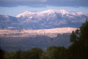
Henry Mountains
The Henry Mountains
Great domes of intrusive igneous rock
pushed into and deformed surrounding sedimentary layers about 70 million years ago.
Erosion later uncovered the domes, revealing mountains towering 5,000 feet above
the surrounding plateau. Mount Ellen's North Summit Ridge (elev. 11,522 ft.) and
Mt. Pennell (elev. 11,320 ft.) top the range. Scenic views and striking geologic
features abound in and around the Henrys. Rock layers tilt dramatically in Waterpocket
Fold to the west and in the Pink Cliffs on the south side of Mt. Hillers. Sheer
cliffs of The Horn, between Mt. Ellen and Mt. Pennell, attract rock climbers.
The arid land and rugged canyons surrounding the Henry Mountains so discouraged early explorers and potential settlers that the range wasn't even named or described until 1869, when members of the Powell river expedition sighted it. Powell later named the range in honor of one of his supporters, Professor Joseph Henry of the Smithsonian Institution. Tales by Indians of a lost Spanish gold mine have long enticed prospectors, yet only modest amounts of the yellow metal were found. Bromide Basin was the major site for gold and silver mines of the past and present. A brief gold boom here in the early 1890s gave rise to Eagle City mining camp along Crescent Creek. The rich vein soon worked out and the town faded away. Other minerals occur in the area too; a uranium mine is just south of the Henrys in Shootaring Canyon, near Ticaboo.
Vegetation ranges from sparse desert plants such as galleta grass and blackbrush on the lower slopes to pinyon pine and juniper woodlands higher up, then to forests of ponderosa pine, aspen, Douglas fir, spruce, and bristlecone pine. Alpine plants and grasslands cover the highest summits. Buffalo, brought to the Henrys from Yellowstone National Park in 1941, form one of the few free-roaming herds in the United States. They winter in the southwestern part of the mountains, then move higher as the snow melts. Mule deer keep mostly to the higher elevations, while pronghorn stay in the desert country to the east. Most of the bighorn sheep are found in the Little Rockies, a southeastern extension of the Henry Mountains. Mountain lions live near the Henrys too, but they're more likely to see you than you are to see them!
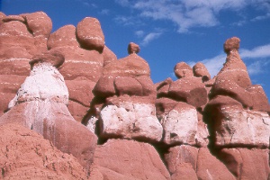 goblins
Thousands of spooky rock formations inhabit Goblin Valley State Park. Little eyelike holes in the "goblins" make you wonder who's watching whom. All of the goblins have weathered out of the Entrada Formation, here a soft red sandstone and even softer siltstone. Carmel Canyon Trail (1.5-mile loop) begins from the northeast side of the parking lot at road's end, then leads into the strange landscape of goblins, spires, and balanced rocks. Just wander about at your whim; this is a great place for the imagination! Curtis Bench Trail begins on the road between the parking lot and the campground and goes south to a viewpoint of the Henry Mountains; cairns mark the 1.5-mile (one way) route. The state park provides a campground with showers on the drive in and a covered picnic area and an overlook at the end of the road. The park stays open all year; Box 637, Green River, UT 84525; tel. 435/564-3633 or 800/322-3770 (reservations). The turnoff from UT 24 is at Milepost 137, 21 miles north of Hanksville and 24 miles south of I-70; follow signs west five miles on a paved road, then south seven miles on a gravel road.
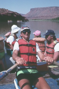 Ed
Crosby takes us down the Colorado River above Moab
Ed
Crosby takes us down the Colorado River above Moab
The most popular run near Moab starts upstream on the Colorado River near Fisher Towers and bounces through several moderate rapids on the way back to town.
 Warner
Lake in La Sals, southeast of Moab
Warner
Lake in La Sals, southeast of Moab
The forests and lakes in Utah's second-highest mountain range provide a dramatic contrast to the barren slickrock and sands of the surrounding desert. Mount Peale (elev. 12,721 ft.) crowns the range at a height nearly 9,000 feet above the Colorado River. Volcanic intrusions formed La Sals about 30 million years ago, twisting and upturning surrounding rock layers at the same time. Streams and glaciers later carved knife-like ridges in the peaks and deep canyons in the foothills. The range comprises three distinct mountain groups in an area about 15 miles long from north to south and six miles wide. Major peaks in the northern part are Mt. Waas (12,331 ft.), Manns Peak (12,273 ft.), and Mt. Tomasaki (12,230 ft.). The middle group contains Mt. Mellenthin (12,646 ft.), Mt. Peale (12,721 ft.), and Mt. Tukuhnikivatz (12,483 ft.). The Indian name of this last mountain is reputed to mean "Land Where the Sun Shines Longest." South Mountain (11,798 ft.) dominates the southern group.
Wildlife you might see includes black bear (one of the state's largest populations lives here), Rocky Mountain elk, mule deer, mountain lion, badger, ringtail cat, porcupine, pika, Merriam's turkey, and golden eagle. Native cutthroat and some brook and brown trout swim in streams at the middle to higher elevations. Reservoirs and Mill Creek contain rainbow trout. Early Spanish explorers, seeing the range when it was covered with snow, named it La Sal ("the Salt"). Other names include "Salt Mountains" and "Elk Mountains." Gold fever peaked here around 1900 with activity concentrated in Miners and Gold basins. Old mines and ruins of former mining camps can still be found in these areas.
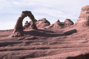 Delicate
Arch, Arches National Park
Delicate
Arch, Arches National Park
Delicate Arch stands in a magnificent setting atop gracefully curving slickrock. Distant canyons and the La Sal Mountains lie beyond. The span is 45 feet high and 33 feet wide. A moderately strenuous hike to the arch begins at Wolfe Ranch and crosses the swinging bridge, climbs a slickrock slope, follows a gully, then contours across steep slickrock to the main overlook. Roundtrip distance is three miles with an elevation gain of 500 feet; carry water. This is one of the most scenic hikes in the park. Just before the end of the trail, walk up to a small arch for a framed view of the final destination. The classic photo of Delicate Arch is taken late in the afternoon when the sandstone glows with golden hues. Another perspective of Delicate Arch, the one in this photo, can be obtained by driving 1.2 miles beyond Wolfe Ranch. Look for the small arch high above. A steep trail (half mile roundtrip) climbs a hill for the best panorama. This famous arch appeared on several Utah Handbook covers.
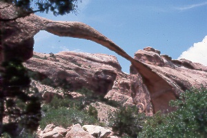 Landscape
Arch on the Devil's Garden Trail in Arches National Park
Landscape
Arch on the Devil's Garden Trail in Arches National Park
Landscape Arch has an incredible 306-foot span (six feet longer
than a football field!). This is one of the longest unsupported rock spans in the
world. The thin arch looks ready to collapse at any moment. A rockfall from the
arch on Sept. 1, 1991 worries some people who fear the end may be near. Height is
106 feet. Distance from the trailhead is two miles round-trip, an easy one-hour
walk.
|
|
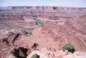 the
Colorado River from Dead Horse Point State Park
the
Colorado River from Dead Horse Point State Park
The land drops away in sheer cliffs from this lofty perch west of Moab. Nearly 5,000 square miles of rugged canyon country lies in the distance. Two thousand feet below, the Colorado River twists through a gooseneck on its long journey toward the sea. The river and its tributaries have carved canyons that reveal a geologic layer cake of colorful rock formations. Even in a region of impressive views around nearly every corner, Dead Horse Point stands out for its exceptional panorama. You'll also see below you, along the Colorado River, the result of powerful underground forces: salt, under pressure, has pushed up overlying rock layers into an anticline. This formation, the Shafer Dome, contains potash that is being processed by the Moab Salt plant. You can see the mine buildings, processing plant, and evaporation ponds (tinted blue to hasten evaporation).
A narrow neck of land only 30 yards wide connects the point with the rest of the plateau. Cowboys once herded wild horses onto the point, then placed a fence across the neck to make a 40-acre corral. They chose the desirable animals in the herd and let the rest go. According to one tale, a group of horses was left behind after such a roundup. Confused by the unusual geography of the point, they couldn't find their way off and circled repeatedly around it. Finally they perished from thirst while within sight of the river below. Besides the awe-inspiring views, the state park offers a visitor center, campground, picnic area, group area, nature trail, and hiking trails. Dead Horse Point is easily reached by paved road, either as a destination in itself, or as a side trip on the way to Island in the Sky District of Canyonlands National Park. From Moab, head northwest 10 miles on US 191, then turn left 22 miles on UT 313. The drive along UT 313 climbs through a scenic canyon and tops out on a ridge with panoramas of distant mesas, buttes, mountains, and canyons. Several rest areas line the road.
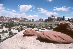 Chesler
Park and the Needles in the Needles District of Canyonlands National Park
Chesler
Park and the Needles in the Needles District of Canyonlands National Park
Chesler Park is a favorite hiking destination. A lovely desert meadow contrasts with the red and white spires that gave the Needles District its name. An old cowboy line camp lies on the west side of the rock island in the center of the park. Chesler Park Trail is about six miles roundtrip; begin from the Elephant Hill Trailhead, three miles past the Squaw Flat Campground turnoff. The trail winds through sand and slickrock before ascending a small pass through the Needles to Chesler Park. Once inside, you can take Chesler Park Loop Trail (five miles) completely around the park. The loop includes the unusual half-mile Joint Trail that follows the bottom of a very narrow crack. Camping in Chesler Park is restricted to certain areas; check with a ranger.
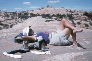 Peggy
Taylor taking a well-deserved rest at the top of Lathrop Trail in the Island in
the Sky District of Canyonlands National Park. We had climbed up from the White
Rim 4WD Road.
Peggy
Taylor taking a well-deserved rest at the top of Lathrop Trail in the Island in
the Sky District of Canyonlands National Park. We had climbed up from the White
Rim 4WD Road.
Lathrop Trail is the only marked hiking route going all the way from Island in the Sky to the Colorado River. Upper trailhead is on the left, 1.3 miles past The Neck on a paved road. The first 2.5 miles crosses Gray's Pasture to the rim, then the trail descends steeply 1,600 feet for most of the next 2.5 miles to the White Rim 4WD Road. Part of this section follows an old mining road past several abandoned mines, all relics of the uranium boom; don't enter the shafts as they're in danger of collapse and may contain poisonous gases. From the mining area, the route descends through a wash to the White Rim 4WD Road, follows the road a short distance south, then goes down Lathrop Canyon Road to the Colorado River, another four miles with a descent of 500 feet. A primitive campground is at the river. Total distance for the strenuous hike is nine miles one way with an elevation change of 2,100 feet. The trail has little shade and can be very hot.
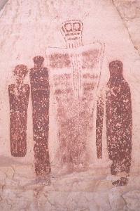
mysterious figures from the past...
pictographs in the "Great Gallery"
Horseshoe Canyon, in a separate section of Canyonlands National Park, contains exceptional prehistoric rock art. Ghostly life-size pictographs in the "Great Gallery" provide an intriguing look into the past. Archaeologists think that the images had religious importance, although the meaning of the figures remains unknown. The Barrier Canyon style of these drawings has been credited to an Archaic Indian Culture beginning at least 8,000 years ago and lasting until about A.D. 450. Horseshoe Canyon also contains rock art left by the subsequent Fremont and Anasazi. The relation between the earlier and later prehistoric groups hasn't been determined. Horseshoe Canyon lies northwest of the Maze District. Two moderately difficult trails and a very rough jeep road lead down the canyon walls.
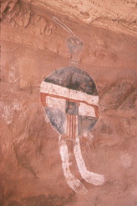 All-American
Man pictograph, Needles District of Canyonlands National Park
All-American
Man pictograph, Needles District of Canyonlands National Park
This colorful artwork overlooks a stone ruin tucked in a small alcove. Hikers can discover this and other rock art when exploring the backcountry. All are fragile and need great care when visited.
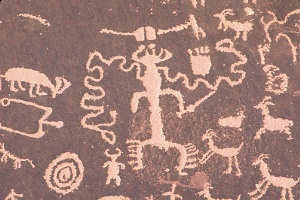
detail, Newspaper Rock Historical Monument
A profusion of petroglyphs at Newspaper Rock depicts human figures, animals, birds, and abstract designs. These represent 2,000 years of human history during which archaic tribes and Anasazi, Fremont, Paiute, Navajo, and Anglo travelers have passed through Indian Creek Canyon. The patterns on the smooth sandstone rock face stand out clearly from the surrounding coating of dark desert varnish. Newspaper Rock lies just 150 feet off UT 211 on the way to the Needles District of Canyonlands National Park. A quarter-mile nature trail introduces you to the area's desert and riparian vegetation. Picnic areas lie along Indian Creek across the highway. The monument is relatively undeveloped; no drinking water or charge. From US 191 between Moab and Monticello, turn west 12 miles on UT 211.
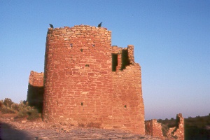 only
ravens now stand guard atop Square Tower Ruins at Hovenweep National Monument
only
ravens now stand guard atop Square Tower Ruins at Hovenweep National Monument
The Anasazi Indians built many impressive masonry buildings during the early to mid-1200s, toward the end of their 1300-year stay in the area. A drought beginning in A.D. 1274 and lasting 25 years probably hastened their migration. Also, several centuries of intensive farming, hunting, and woodcutting had already taken their toll on the land. Archaeologists believe that the inhabitants retreated south in the late 1200s to sites in northwestern New Mexico and northeastern Arizona. The Ute Indian word Hovenweep means "Deserted Valley," an appropriate name for the lonely high-desert country left behind. The Anasazi at Hovenweep had much in common with the Mesa Verde culture, though the Dakota Sandstone here doesn't form large alcoves suitable for cliff-dweller villages. Ruins at Hovenweep remain virtually unexcavated, awaiting some future archaeologist's trowel.
The Anasazi farmers had a keen interest in the seasons because of their need to know the best time for planting crops. Astronomical stations (alignments of walls, doorways, and tiny openings) allowed the sun priests to determine the equinoxes and solstices with an accuracy of one or two days. This precision also may have been necessary for a complex ceremonial calendar. Astronomical stations at Hovenweep have been discovered at Hovenweep Castle and Unit-Type House of Square Tower Ruins and at Cajon Ruins. Hovenweep National Monument protects six groups of villages left behind by the Anasazi. The sites lie near the Colorado border southeast of Blanding, Utah. Square Tower Ruins Unit, where the visitor center is located, has the greatest number of ruins and the most varied architecture. In fact, you can find all of the Hovenweep architectural styles here. The visitor center has a few exhibits on the Anasazi and photos of local wildlife.
|
|
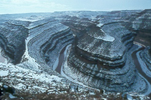 Goosenecks
of the San Juan River after a January snowstorm, northwest of Mexican Hat
Goosenecks
of the San Juan River after a January snowstorm, northwest of Mexican Hat
Goosenecks State Park
The San Juan River winds through a
series of incredibly tight bends 1,000 feet below. So closely spaced are the bends
that the river takes six miles to cover an air distance of only 1.5 miles! The bends
and exposed rock layers form exquisitely graceful curves. Geologists know the site
as a classic example of entrenched meanders, caused by gradual uplift of a formerly
level plain. Signs at the overlook explain the geologic history and identify the
rock formations. Goosenecks State Park is an undeveloped area with a few tables
and vault toilets as the only facilities. You could camp here; no water or charge.
From the junction of US 163 and UT 261, four miles north of Mexican Hat, go one
mile northwest on UT 261, then turn left three miles on UT 316 to its end.
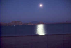
moon over Navajo Mountain and
Lake Powell, from Lone Rock Beach
The vast Glen Canyon National Recreation Area covers 1.25 million acres, most of which spreads northeast from Glen Canyon Dam into Utah. Lake Powell stands out as the centerpiece, surrounded by beautiful canyon country. Just a handful of roads approach the lake, so you'll need to do some boating or hiking to explore this unique land of water and rock. The recreation area also includes a beautiful remnant of Glen Canyon in a 15-mile section of the Colorado River from Glen Canyon Dam to Lees Ferry.
Conservationists deplored the loss of remote and beautiful Glen Canyon of the Colorado River beneath Lake Powell. Today, we have only words, pictures, and memories to remind us of its wonders. On the other hand, the 186-mile-long lake now provides easy access for many people to an area most had not even known existed. Lake Powell is the second largest man-made lake within the United States. Only Lake Mead, farther downstream, has a greater water-storage capacity. Lake Powell, however, has three times more shoreline—1,960 miles—and holds enough water to cover the state of Pennsylvania a foot deep! Bays and coves offer nearly limitless opportunities for exploration by boaters. Nearly all of the lake lies within Utah. Only the lower parts—Glen Canyon Dam, Wahweap Resort and Marina, Antelope and Navajo canyons, and the lower parts of Labyrinth, Face, and West canyons—lie in Arizona. The elevation of the surface fluctuates 20-30 feet through the year and peaks in July; Lake Powell reaches an elevation of 3,700 feet when full. The Carl Hayden Visitor Center, perched beside the dam, has tours of the dam, related exhibits, and an information desk for all the Glen Canyon National Recreation Area.
 collared
lizard (Crotaphytus collaris) sunning at Hovenweep National Monument
collared
lizard (Crotaphytus collaris) sunning at Hovenweep National Monument