 downtown
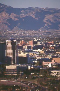
Tucson and the University of Arizona against a backdrop of the Santa Catalina Mountains
downtown
Tucson and the University of Arizona against a backdrop of the Santa Catalina Mountains
downtown
Tucson and the University of Arizona against a backdrop of the Santa Catalina Mountains
Though the Old Pueblo, as it's known locally, is modern and lively, Tucson's
Old West heritage will surprise you. Tucson (TOO-sawn) has some of the finest cultural
offerings in Arizona—a large university, historic sites, fine museums, and
a great variety of restaurants and nightlife. Yet you can actually walk this city
and see most of its sights. Set in a desert valley at an elevation of 2,400 feet,
Tucson ranks as the state's second-largest city, with a metropolitan population
of more than 900,000. Summers are warm, but not as hot as those in Phoenix or Yuma.
And cool Mt. Lemmon at 9,157 feet in the Santa Catalinas is just an hour's drive
away.
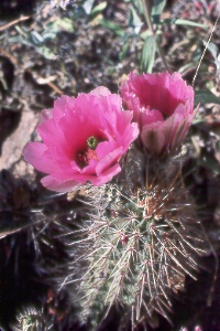 hedgehog cactus (Echinocereus sp.) at the Arizona-Sonora Desert Museum This world-famous living museum contains animals and plants native to the Sonoran Desert of Arizona, the Mexican state of Sonora, and the Gulf of California region. It’s in Tucson Mountain Park, 14 miles west of Tucson. |
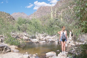 hiking
up Bear Canyon in the Santa Catalina Mountains, northeast of Tucson
hiking
up Bear Canyon in the Santa Catalina Mountains, northeast of Tucson
Bear Canyon
This beautiful desert canyon east of Sabino Canyon
features Tucson's most popular hiking destination—Seven Falls,
a series of waterfalls, each with a pool at its base. Some of the pools are large
enough for swimming, a great way to cool off in the warmer months. You have the
option of hiking from the Sabino Canyon Visitor Center or taking the Bear Canyon
shuttle for the first 1.5 miles. Bear Canyon Trail begins just south of the visitor
center, crosses some rolling foothills to Bear Canyon (1.5 miles one way), then
turns up the canyon to Seven Falls (3.8 miles total, one way). The trail continues
half a mile more to connect with other trails in the Catalinas. On the hike to Seven
Falls you'll cross the creek seven times, make a gentle climb onto the east hillside,
then descend to the falls. The water-polished rock surrounding the pools requires
care in walking as it's very slippery. Allow about 4.5 hours for the roundtrip,
3.5 hours if starting from the Bear Canyon shuttle terminus; elevation change is
650 feet for this easy hike. Picnic tables nestle beside Sabino Creek and at Bear
Canyon Overlook along the way. The shuttle bus leaves the visitor center for the
short ride east to Bear Canyon if you'd like to skip the first 1.5 miles of hiking;
the canyon scenery doesn't begin until you leave the road, so there's no point in
taking this shuttle unless you plan on hiking. Bicyclists may not ride into Bear
Canyon because it lies in Pusch Ridge Wilderness, but they may take the road to
the mouth of the canyon.
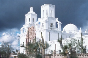 San
Xavier Mission, south of Tucson
San
Xavier Mission, south of Tucson
This gleaming white church rises from the desert as a testimonial to the faith
of early Spanish missionaries and the Tohono O'odham Indians. One of the finest
pieces of Spanish colonial architecture in the United States, its beauty has given
rise to the name White Dove of the Desert. Padre Kino first visited the site in
1692, and a chapel went up in 1700. The church's name honors Kino's patron saint.
The Indian village name of Wa:k or Bac means "where the water comes
out of the ground."
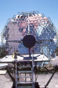 look
closely and you'll see Bill's reflection photographed at the f2 point of the Cosmic
Ray Telescope at Whipple Observatory, south of Tucson!
look
closely and you'll see Bill's reflection photographed at the f2 point of the Cosmic
Ray Telescope at Whipple Observatory, south of Tucson!
Whipple Observatory
The Smithsonian Institution studies the
heavens with a variety of telescopes on Mt. Hopkins. The famous Multiple Mirror
Telescope, one of the world's largest, has been replaced by a new telescope with
a single giant 6.5-meter mirror using the latest optical and electronic technologies.
Its 4.5-story building weighs 550 tons; the entire structure turns to aim the telescope.
From March to November, six-hour tours begin at the Whipple Observatory's visitor center at the base of the Santa Ritas. The tour begins with a short video presentation at 9 a.m., then you have a narrated bus ride high into the mountains. It's great to let the experienced bus driver tackle the narrow, winding mountain road, stopping at a ten-meter-diameter reflector for gamma ray studies and other telescopes along the way, where the guide introduces astronomy and local history and points out distant summits. The outstanding views are almost as good as those from nearby Mt. Wrightson. You may be able to pick out the Guillermo Haro Astrophysical Observatory 56 miles south-southeast in Mexico. The tour takes a mid-day break atop Mt. Hopkins for a picnic (bring your own lunch). Be prepared for temperatures 15-20� cooler than in the valley, possible summer showers, and the thin air at Mt. Hopkins' 8,550-foot summit. Call up to four weeks in advance for the schedule (generally Mon., Wed., and Fri.), directions, and required reservations; tel. 520/670-5707.
The visitor center is open year-round Mon.-Fri. 8:30 a.m.-4:30 p.m. with exhibits
and video programs; free admission. From Tucson, head south on I-19 to Canoa Exit
56, then follow signs 11.5 miles. From the I-19 exit, you'll go south along the
east frontage road, east on Elephant Head Road, then southeast on Mt. Hopkins Road;
all these are paved. The visitor center is 43 miles south from Tucson or 38 miles
north from Nogales. You can also head up the Mt. Hopkins Road on your own for views
and a few undeveloped spots for picnicking or camping; a gate 7.5 miles past the
visitor center blocks the remaining five miles to the top, though you can walk on
this road.
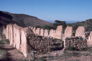
cavalry barracks at Fort Bowie National Historic Site
On July 15, 1862, Brigadier General James Carleton and his California Column were on their way to meet the threat posed by the Confederate invasion of New Mexico when an advanced detachment, under the command of Captain Thomas Roberts, was attacked by Indians at Apache Pass. Roberts fended them off but suggested to Carleton the need for a fort. The original Fort Bowie was built within a month. Indian raids continued until 1872, when Cochise made peace with the Army in exchange for reservation land.
Bad management by the Indian Bureau, followed by the government's taking back much of the reservation, angered many Apache. Cochise had died on the reservation, but Geronimo, the wily Apache leader, led bands of followers into Mexico in 1881 and began a new series of raids. Army cavalry and scouts from Fort Bowie and other posts sought out the elusive Indians. Geronimo's small band was the last to surrender, five years later, ending Arizona's Indian wars. The fort was abandoned on October 17, 1894.
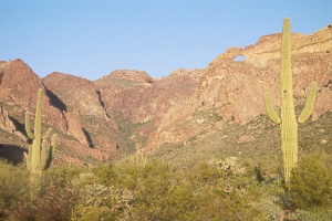 Ajo
Mountains at sunset, from Ajo Mountain Drive in Organ Pipe Cactus National Monument,
southwest of Tucson
Ajo
Mountains at sunset, from Ajo Mountain Drive in Organ Pipe Cactus National Monument,
southwest of Tucson
Heading into the rugged country of the eastern part of the monument, Ajo Mountain
Drive reveals many spectacular views. Most of the 21-mile gravel loop road is one-way;
pick up a pamphlet describing the drive at the visitor center or at the start of
the loop, just across the highway from the visitor center; allow at least two hours.
Mountain bikers enjoy the loop, which they can ride in either direction.
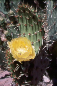 prickly
pear cactus (Opuntia sp.) in Estes Canyon at Organ Pipe Cactus
National Monument prickly
pear cactus (Opuntia sp.) in Estes Canyon at Organ Pipe Cactus
National MonumentIn addition to the large spines—actually modified leaves—found on other cactus, prickly pears also have tiny barbed spines called "glochids." These are difficult to see, detach easily, and can be tricky to remove once in your skin. Prickly pears produce edible fruits; the pads can also be cooked and eaten as a vegetable, though the glochids and spines pose a considerable deterrent. More than a dozen species grow in North American deserts. |
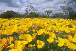
|
With good winter rains, these and other annuals bloom in the desert from about February to April. |
 Sierra
Pinta from El Camino Diablo, southwest of Tucson
Sierra
Pinta from El Camino Diablo, southwest of Tucson
Cabeza Prieta National Wildlife Refuge
The 860,000 acres
of desert wilderness west of Organ Pipe Cactus National Monument hasn't changed
much since white people arrived. The region has no facilities, no paved roads, no
running water. Desert bighorn sheep, for which the refuge was founded in 1939, and
the endangered Sonoran pronghorn receive protection here. Much of the refuge has
wilderness designation. Twelve small mountain ranges rise above the desert floor.
Wildlife and vegetation are similar to those in Organ Pipe Cactus National Monument,
but the climate is harsher. Cabeza Prieta's annual rainfall averages about nine
inches in the east and three inches in the west. Some areas go for more than a year
without rain.
On to Photos of Western Arizona
Back to beginning of Photo Gallery
Home