 a
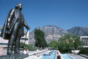
statue of Brigham Young on the campus of BYU
a
statue of Brigham Young on the campus of BYU
a
statue of Brigham Young on the campus of BYU
Brigham Young University had a modest beginning in 1875 as the Brigham Young Academy, established under the direction of Mormon Church President Brigham Young. Like the rest of Provo, BYU has grown dramatically in recent decades. BYU is one of the largest church-affiliated schools in the world. The 29,000 students come from every state in the nation and 90 foreign countries. Students aren't required to be Mormons, but about 95% do belong to the LDS Church. High academic standards upheld by the students and the faculty have made the university a leader in many fields. Everyone attending the school must follow a strict dress and grooming code—something you'll notice immediately on a stroll across the modern campus.
You're welcome to visit the more than 600 acres of BYU's vast campus. The visitor center provides literature and advice about things to see, events, and facilities open to the public on the brow of the hill near Maeser Building, south on Campus Drive; tel. 801/422-4678, www.byu.edu. Campus tours, either on foot or in small open-air vehicles, introduce the university; student guides point out features of interest and tell about student life and research work.
|
|
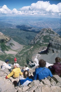 view
to the east from the summit of Mt. Timpanogos; Emerald Lake lies below and
Deer Creek Reservoir is in the distance. view
to the east from the summit of Mt. Timpanogos; Emerald Lake lies below and
Deer Creek Reservoir is in the distance. |
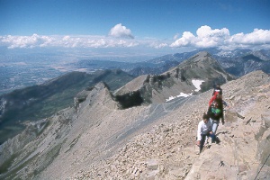
| Sheer cliffs of Mt. Timpanogos tower 7,000 feet above
the Utah Valley and present one of the most dramatic sights of the Wasatch
Range. Trails to the heights lead past waterfalls, flower-filled alpine
meadows, lakes, and permanent snowfields. One trail continues to the 11,750-foot
summit for superb vistas of central Utah. The climb is strenuous, especially
the last three miles, but requires no special skills. You'll see whole families—from
grandchildren to grandparents—on this popular mountain. Even short
hikes can be very rewarding. Take care to bring storm gear in case the weather
suddenly turns bad. A shelter at Emerald Lake provides a refuge from storms.
Hike either the Timpooneke Trail from Timpooneke Campground
or Aspen Grove Trail from Theatre in the Pines Picnic Area;
both trailheads lie just off the Alpine Scenic Loop. One-way distances to
the summit are 9.1 miles on the Timpooneke Trail (4,350-foot elev. gain)
and 8.3 miles on the Aspen Grove Trail (4,900-foot elev. gain). A hike using
both trails (highly recommended) can be done with a car shuttle. If a trip
to the summit sounds too ambitious, you can hike just the 12 miles between
the trailheads via Emerald Lake (elev. 10,300 ft.). The Summit Trail branches off west of Emerald Lake, climbs a steep slope to the jagged summit ridge, then follows the ridge southeast to the top. A large snowfield and the deep blue waters of Emerald Lake, which is passed on the Aspen Grove Trail, lie directly below. Chunks of ice break off the snowfield and float in the lake during even the hottest summer days. Local people often refer to the snowfield as a glacier, but technically it's just a snowfield. Some climbers continue southeast along the summit ridge and drop down onto the snowfield and slide or walk to Emerald Lake, but this can be a bit hazardous. Hiking season is from about mid-July to mid-October. In winter and spring, hikers must be equipped and experienced for snow travel. Topo maps are the 7.5-minute Timpanogos Cave and Aspen Grove, though you're not likely to need them unless snow covers the trails. The Pleasant Grove Ranger District office can advise on hiking conditions; 390 N. 100 East, Pleasant Grove, UT 84062, tel. 801/785-3563. |
|
|
|
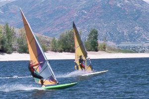 sailboarding
on Deer Creek Reservoir, southwest of Heber City
sailboarding
on Deer Creek Reservoir, southwest of Heber City
Deer Creek State Park
The seven-mile-long Deer Creek Reservoir
lies in a very pretty setting below Mt. Timpanogos and other peaks of the Wasatch
Range. A developed area near the lower end of the lake has a campground with showers,
picnic area, paved boat ramp, dock, and fish-cleaning station; elevation is 5,400
feet. Island Beach Area, 4.5 miles to the northeast, has a gravel swimming beach
and a marina (open in summer with a store, snack bar, boat ramp, and rentals of
fishing boats, ski boats, and jet skis); ice fishermen can park here in winter.
Rainbow trout, perch, largemouth bass, and walleye swim in the lake. Good winds
for sailing blow most afternoons. You'll often see a lineup of catamarans at the
sailboat beach near the campground and crowds of sailboarders at the Island Beach
Area. Deer Creek State Park is open mid-April to late Sept.; Box 257, Midway, UT
84049; tel. 435/654-0171 (reservations advised Memorial Day to Labor Day weekends).
The campground is just off US 189, 11 miles southwest of Heber City and 17 miles
northeast of Provo.
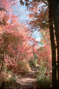 Rocky
Mountain maples near Cascade Springs, west of Heber City
Rocky
Mountain maples near Cascade Springs, west of Heber City
Crystal-clear water of Cascade Springs emerges amidst lush vegetation and flows
down a long series of travertine terraces at this beautiful spot. The springs produce
more than seven million gallons of water daily. Boardwalks, some wheel-chair accessible,
and short trails with interpretive signs allow a close look at the stream and pools.
Trout can be seen darting through the water (no fishing). Plant life includes maple,
oak, aspen, willow, water birch, box elder, cattails, watercress, and wildflowers.
The drive to Cascade Springs is also very pretty, either from the Alpine Scenic
Loop or from Heber Valley. A paved road (Forest Road 114) branches off the Alpine
Scenic Loop near its summit (between Mileposts 18 and 19) and winds northeast seven
miles to the springs. An unpaved road, passable by car if the road is dry, begins
on the west edge of Heber Valley and climbs high above the valley with good views,
then drops down to the springs; turn west seven miles on UT 220 from UT 113 (between
Midway and Charleston) and follow signs.
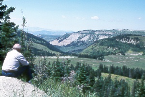 enjoying
a view of the Wasatch Plateau from Skyline Drive
enjoying
a view of the Wasatch Plateau from Skyline Drive
This scenic back road, nearly all unpaved, follows the crest of
the Wasatch Plateau for about 100 miles between US 6 in the north and I-70 in the
south. Few people travel the entire length, however, preferring to do shorter sections
reached from the many access roads. Much of the drive lies above 10,000 feet in
vast meadows and alpine forests; you'll reach an elevation of 10,897 feet at High
Top, the drive's summit (above Ferron Reservoir). Major attractions include the
sweeping vistas, fishing, hiking, horseback riding, and winter sports.
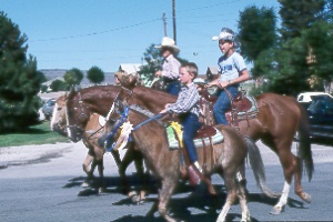 riding
in the Wayne
riding
in the Wayne
County Fair parade in Loa
Pioneers settled here in the mid-1870s. A former Mormon missionary
who had served in Hawaii suggested the town's unusual name. A commemorative marker
(next to the 1897 Loa Tithing House, on Center St. one block west from Main) has
a rock from Mauna Loa. The small town is the Wayne County seat and a handy base
for exploring the Fish Lake area to the north. Wayne County Fair on the third weekend
in August has a parade, rodeo, exhibits, barbecue, and games.
On to Photos of Northeastern Utah
Return to beginning of Photo Gallery
Home