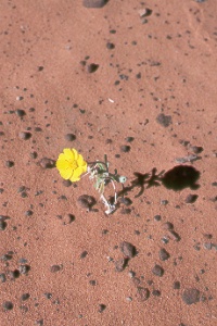
 a
lonely wildflower on Hidden Pińon Trail in Snow Canyon State Park, northwest of
St. George
a
lonely wildflower on Hidden Pińon Trail in Snow Canyon State Park, northwest of
St. George
a
lonely wildflower on Hidden Pińon Trail in Snow Canyon State Park, northwest of
St. George
The park is a great place to explore and enjoy the desert scenery. Red-rock canyons, sand dunes, volcanoes, and lava flows have formed an incredible landscape. Walls of Navajo Sandstone 500-750 feet high enclose five-mile-long Snow Canyon. Hiking trails lead into the backcountry for a closer look at the geology, flora, and fauna. Common plants are barrel, cholla, and prickly pear cacti, yucca, Mormon tea, shrub live oak, cliffrose, and cottonwood. Delicate wildflowers bloom mostly in the spring and autumn, following the wet seasons, but cactus and the sacred datura can flower in the heat of summer. Wildlife include the sidewinder and Great Basin rattlesnakes, Gila monster, desert tortoise, kangaroo rat, squirrels, cottontail, kit fox, coyote, and mule deer. You may find some Indian rock art, arrowheads, bits of pottery, and ruins. Many of the place names in the park honor Mormon pioneers. Snow Canyon was named for Lorenzo and Erastus Snow—not for the rare snowfalls. Cooler months have the best weather; summers are too hot for comfortable hiking except in early morning. Highway UT 18 leads past an overlook on the rim of Snow Canyon and to the paved park road (UT 300) that drops into the canyon and follows it to its mouth and the small town of Ivins. Snow Canyon is about nine miles northwest of St. George. It's reached either by UT 18, the faster way, or via Santa Clara and Ivins. Contact Snow Canyon State Park at 1002 Snow Canyon Drive, Ivins, UT 84738; tel. 435/628-2255 or 800/322-3770 (reservations).
 Greenshow
actors of the Utah Shakespearean Festival, Cedar City
Greenshow
actors of the Utah Shakespearean Festival, Cedar City
The enthusiasm of the actors and the community make this summer event come alive. The festival has such a high reputation and provides such a good learning experience that all participate eagerly. Their enthusiasm is contagious, and visitors soon find themselves caught up in the spirit. The festival presents three Shakespearean plays each season, choosing from both the well-known and the rarely performed works. The management's long-term goal is to produce every play from the Shakespeare canon! Most of the action centers on one of the most authentic Elizabethan stages in the world. Three additional plays come from other great playwrights such as Chekhov, Moliere, and Arthur Miller—the "Best of the Rest"—and take place in the nearby Randall Jones Theatre.
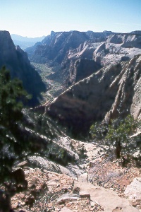 view
down Zion Canyon from Observation Point,
view
down Zion Canyon from Observation Point,
at the end of Observation Point Trail
in Zion National Park
This strenuous trail climbs 2,150 feet in 3.6 highly scenic miles to Observation Point (elev. 6,507 ft.) on the east edge of Zion Canyon. Allow about six hours for the roundtrip. Trails branch off along the way to Hidden Canyon, upper Echo Canyon, East Entrance, East Mesa, and other destinations. The first of many switchbacks begins a short way up from the trailhead for Weeping Rock. You'll reach the junction for Hidden Canyon Trail after 0.8 mile. Several switchbacks later, the East Rim Trail enters sinuous Echo Canyon. This incredibly narrow chasm can be explored for short distances upstream and downstream to deep pools and pour-offs. Echo Canyon Trail branches to the right at about the halfway point; this rough trail continues farther up the canyon and connects with trails to Cable Mountain, Deertrap Mountain, and the East Entrance Station (on Zion-Mt. Carmel Highway). The Observation Point Trail then climbs slickrock slopes above Echo Canyon with many fine views. Parts of the trail are cut right into the cliffs. You'll reach the rim at last after three miles of steady climbing. Then it's an easy 0.6 mile through a forest of pinyon pine, juniper, Gambel oak, manzanita, sage, and some ponderosa pine to Observation Point. Impressive views take in Zion Canyon below and mountains and mesas all around. East Mesa Trail turns right about 0.3 mile before Observation Point and follows the plateau northeast to a dirt road outside the park.
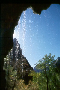 Weeping
Rock, Zion National Park
Weeping
Rock, Zion National Park
A favorite with visitors, Weeping Rock Trail winds past lush vegetation and wildflowers to a series of cliffside springs above an overhang. Thousands of water droplets glisten in the afternoon sun. The springs emerge where water seeping through more than 2,000 feet of Navajo Sandstone meets a layer of impervious shale. The paved trail is 0.5 mile roundtrip with a 100-foot elevation gain. Signs along the way identify some of the trees and plants.
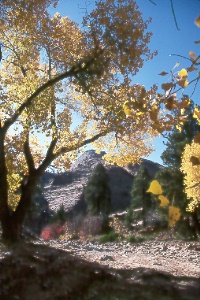 cottonwoods
and slickrock along the Zion-Mt. Carmel Highway, east of Zion Canyon
cottonwoods
and slickrock along the Zion-Mt. Carmel Highway, east of Zion Canyon
The east section of Zion National Park is a land of sandstone slickrock, hoodoos, and narrow canyons. You can see much of the pretty scenery along the Zion-Mt. Carmel Highway (UT 9) between Zion Canyon and the East Entrance Station. Most of this region invites exploration on your own. Try hiking a canyon or heading up a slickrock slope. (The pass between Crazy Quilt and Checkerboard mesas is one possibility.) Highlights on the plateau include a hike on the Canyon Overlook Trail (begins just east of the long tunnel) and views of the White Cliffs and Checkerboard Mesa (both near the East Entrance Station). Checkerboard Mesa's distinctive pattern is due to a combination in the bedrock of vertical fractures and horizontal bedding planes, both accentuated by weathering. The highway's spectacular descent into Zion Canyon goes first through a 530-foot tunnel, then a 5,600-foot tunnel, followed by a series of six switchbacks to the canyon floor. Because of the narrowness of the long tunnel (completed in 1930) and the growing numbers of large vehicles visiting Zion, it's necessary for them to travel through in one-way traffic: any vehicle over 7 feet 10 inches wide, over 11 feet 4 inches high, or more than 40 feet long (50 feet with trailer) is charged a fee at the tunnel. Bicycles must be transported through the tunnels (it's too dangerous to ride).
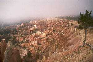 Bryce
Amphitheater from Sunrise Point, Bryce Canyon National Park
Bryce
Amphitheater from Sunrise Point, Bryce Canyon National Park
A geologic fairyland of rock spires rises beneath the high cliffs of the Paunsaugunt Plateau. This intricate maze, eroded from a soft limestone, now glows with warm shades of reds, oranges, pinks, yellows, and creams. The rocks provide a continuous show of changing color through the day as the sun's rays and cloud shadows move across the landscape. Visitors perceive a multitude of wondrous forms. The natural rock sculptures can be Gothic castles, Egyptian temples, a subterranean world inhabited by dragons, or vast armies of a lost empire. Paiute Indians related a tale of the Legend People, various animals and birds living in a beautiful city built for them by Coyote. The Legend People then began behaving badly toward Coyote, who transformed them all into stone. Bryce Canyon National Park contains some of the best scenery, though what's popularly called Bryce Canyon isn't a canyon at all, but the largest of a series of massive amphitheaters cut into the Pink Cliffs. You can gaze into the depths from viewpoints and trails on the plateau rim or descend moderate grades winding among the spires. More of the park can be seen along a 17-mile scenic drive south past Bryce Canyon to other overlooks and trailheads. The nearly 36,000 acres of Bryce Canyon National Park offers many opportunities to explore spectacular rock features, dense forests, and expansive meadows. A variety of wildlife and plant communities make their homes in the park.
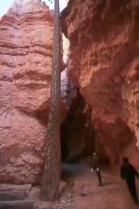 Wall
Street, Bryce Canyon National Park
Wall
Street, Bryce Canyon National Park
From Sunset Point, Navajo Loop Trail drops 520 feet in three quarters of a mile through a narrow canyon. At the bottom, the loop leads into the deep, dark Wall Street—an even narrower canyon half a mile long—then returns to the rim; total distance is about 1.5 miles. Other destinations from the bottom of Navajo Trail are Twin Bridges, Queen's Garden Trail, Peekaboo Loop Trail, and the town of Tropic. The 1.5-mile trail to Tropic isn't as scenic as the other trails, but it does provide another way to enter or leave the park; ask at the visitor center or in Tropic for directions to the trailhead.
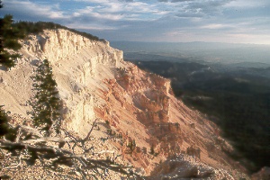 Powell
Point
Powell
Point
Even in a state with many superb viewpoints, Powell Point (elev. 10,188 ft.) is outstanding. Yet surprisingly few people know about this lofty perch at the south tip of the Table Cliff Plateau, a southwestern extension of the Aquarius Plateau. Its light-colored cliffs stand about 15 air miles northeast of Sunset Point in Bryce Canyon National Park. Getting to Powell Point involves a bit of adventure. Cars with good clearance can be driven within 4.3 miles of the point; high-clearance vehicles can go to within 0.6 mile of it. From the highway junction north of Bryce National Park, drive northeast 11 miles on UT 63 (gravel), turn southeast six miles to Pine Lake, continue east six miles on Forest Road 132 up onto the plateau, then look for the one-lane dirt road on the right to Powell Point; high-clearance vehicles can turn in 3.7 miles to the Powell Point trailhead. If you're not equipped for driving this rough road, you'll still find it good for hiking or mountain bicycling. The road ends where the ridge becomes too narrow for it; the clearing here is fine for camping (no facilities). A foot trail continues 0.6 mile to the very end of Powell Point. On the way you'll pass through an extremely weather-beaten and picturesque forest of bristlecone and limber pine. Panoramic views begin well before trail's end and at the point itself you'll feel as though you're at the end of the world. Much of southern Utah and northern Arizona stretches out below to the far horizon. The colorful cliffs of the Claron Formation lie directly underfoot; take care near the crumbly cliff edges. Avoid Powell Point if thunderstorms threaten. (Note the many lightning scars on trees here!) The Escalante Ranger District office has current road conditions to Powell Point; tel. 435/826-5400.
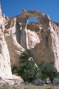 Grosvenor
Arch
Grosvenor
Arch
southeast of Bryce Canyon National Park
Dirt roads between Kodachrome Basin State Park and US 89 (between
Mileposts 17 and 18) lead to this magnificent double arch. The largest of the two
openings is 99 feet across. The 1949 National Geographic expedition named the arch
in honor of the society's president. Check directions and road conditions at Kodachrome
Basin State Park (southeast of Bryce Canyon National Park) or at Paria Ranger Station
(on US 89 near Milepost 21).
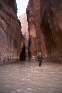 in
the Narrows of Paria Canyon
in
the Narrows of Paria Canyon
The wild and twisting canyons of the Paria River and its tributaries
offer a memorable experience for experienced hikers. Silt-laden waters have sculpted
the colorful canyon walls, revealing 200 million years of geologic history. You
enter the 2,000-foot-deep gorge of the Paria in southern Utah, then hike 38 miles
downstream to Lees Ferry in Arizona, where the Paria empties into the Colorado River.
Besides the canyons, this 110,000-acre wilderness area protects colorful cliffs,
giant natural amphitheaters, sandstone arches, and parts of the Paria Plateau. Wonderful
swirling patterns in sandstone hills, known as the "Coyote Buttes," enthrall
visitors on top of the plateau. The 1,000-foot-high, rosy-hued Vermilion Cliffs
meet the mouth of Paria Canyon at Lees Ferry. The river's name, sometimes spelled
Pahreah, is Paiute for "muddy water."
On to Photos of Southeastern Utah
Return to beginning of Photo Gallery
Home